

The Republic of Namibia, country number four on my journey through Southern Afrika and what a country it turned out to be, it was totally incredible. Long straight lonely roads running through desert like landscapes, with massive granite mounds of rock rising up through the sand reaching up to try to touch the incredible blue sky, or mountain high boulders piled up by some prehistoric giant, long ago, in a forgotten time. You drive for hours, and you see no one. On its western side it has the Atlantic ocean crashing onto its rocky desolate coastline. In the north it borders with Angola and Zambia. It borders Botswana in the East and South Africa to the South. It gained independence from South Africa in 1990. It was a former German colony with a turbulent history. The Germans ruled from 1884 to 1915 when they were defeated by the South African forces. Namibia finally achieved independence in 1990. It is ruled now by a democratically elected parliament. It is one of the least populated countries in the world, with a population of just 2.55 million people. It is also the driest country in Sub Sahara Africa. Taking into account the sparse population, the dry climate and the heat, road trips become an adventure never to be forgotten. There is a small network of main roads that are sealed with tarmac. But most of the roads are gravel, sand, or dirt over bad washboard, liberally scattered with stones and rocks and can be extremely challenging. Its main source of income comes from the Tourist, Agriculture and the Mining sectors. The mining is for gemstones, diamonds, uranium, gold, silver and base metals.

And Now For Something Completely Different:
Most of my friends know that I hate sand but love deserts. Sand and two wheels were never a success story with me. Also, most of my friends know that I never, or hardly ever drive cars or anything with more than three wheels so you will all be surprised to learn that I hired a fully equipped, for camping, Toyota Land Cruiser, with a rooftop tent. There were a number of reasons that prompted this. The roads are really badly corrugated in places and the risk of damaging the bike was really high. Also, Susie flew out to Namibia to join me in this exercise in madness. Also, I am not allowed into any of the Namibian parks with the bike. I would have to have done expensive excursions with tour operators. So, it worked out cheaper in the long run to hire a 4×4 and as an extra bonus I had my accommodation and meals. Also, I had a co-driver in Susie.
From Upington, South Africa, to the Namibian border was just 133 km. But it was really flat desolate countryside with no towns along the way.

The border crossing was easy but time consuming. This time, on the RSA side, there was a border guard who knew what to do with my Carnet. The border post was geared more for Trucks and shared Taxi’s with just the odd foreigner passing through. The Namibian post was 16 Kms further down the road at a place called Ariamsvlei. Here, they were stuck in the bureaucratic, form filling era. I had to fill out loads of different forms for Immigration and for temporary import for the bike. Then there was the cross-border fee. This is a fixed amount like a road tax, it’s a small amount. All in all, it took just over a hour.

I stopped in a town called Karasburg. Rented a little self-catering chalet. This town was like something out of a movie. Just a collection of houses in the middle of a sandy wilderness. Also, it was a Saturday and everything shut down at one o’clock, it was dead. My first impression of Namibia, a hot, deserted, desert land with straight roads.

My first impression of Namibia
The next day was more straight roads with a stop in Mariental for the night. Some of the petrol stations are really something else. One that I stopped at in the middle of nowhere was like a scene out of the 1972 hillbilly film Deliverance. People sitting, leaning, or just stood, staring at me and the bike, add in a hot desert wind blowing sand and dust and nothing for as far as the eye can see…. Really surreal.

Petrol station in the middle of nowhere… Namibia
Then as I approached Windhoek the scenery started to change. Green instead of sand and crops and farms started to appear and once again there was traffic on the road.

The scenery started to change…

This was an actual roadside restaurant just outside Mariental
But also, the weather was changing… Rain. Just before Windhoek I put on my wet weather gear and then it really rained. A tropical storm. I sheltered at a large petrol station on the outskirts of Windhoek and the Heavens just opened up. Thunder, lightning, and rain interspersed with hailstones. It went on for hours. Then a large bolt of lightning came and an almighty clap of thunder and the power went out in the petrol station. They had an emergency generator and that kicked in. This was my welcome to Windhoek.

I was in Windhoek to meet up with Susie who was flying in from Amsterdam and to pick up the “De Bakkie” a Toyota Land cruiser.

Our guesthouse African Kwela in Windhoek

Weaver bird with her nest in our guesthouse
Windhoek is the capital of Namibia but it’s a small city compared to other cities in Africa. It has a really strange layout. Suburbia is like scattered settlements, interspersed with waste land and then you are right bang in the city center. Bought a Namibian sim card for my phone, met Susie at the airport, spent a day or two exploring Windhoek then it was time to go pick up “De Bakkie” from Bushlore.

The Meteorites Windhoek

The Zoo Park Windhoek

Café Zoo-La Marmite Royale under Windhoek’s best loved giant rubber tree

Leaving to Bushlore to pick up our Bakkie
To say that I was nervous was an understatement. I had arranged with them to leave Tiggy Moon Dust locked up on their premises. First look at the “De Bakkie” and I thought Crap this is big. Then came a hectic couple of hours where I got a crash course in how to handle this contraption and what was what and what it was for. How a high lift jack worked, how the winch worked, lowering and raising the air pressure, for different terrain, in the tyres…. That, at least, was the same as the bike. How to erect and pack up the roof top tent, the list was endless. Then I had the keys in my hand, and they said good luck and that was that.

Crash course in how to handle this contraption… De Bakkie

Tiggy Moondust ready to be locked up on premises of Bushlore

Ready to go...
I was in the middle of downtown Windhoek traffic where they drive on the left, in what felt like a tank. I managed to navigate “De bakkie” to a large supermarket to stock up on provisions without hitting anything. Then it was on to the Daan Viljoen Wildlife Reserve for our first night. This is a small reserve just outside of Windhoek. This was to give us a feel for the contraption, but we also saw some blue wildebeest and warthogs. The word “Bakkie” is South Afrikaans for pickup truck and “de” is “the”. It is used extensively, and it stuck… we now had a “bakkie” of our own.

Off we go


Daan Viljoen Game Reserve

Blue wildebeest
Our next stop was Etosha National Wildlife Reserve. The main feature of Etosha is the abundance of game wandering around. The elephants are some of the biggest in Africa. This is because the ground and vegetation are rich in nutrients and vitamins. Etosha is, also, home to lions, leopards, cheetahs, black rhinos, giraffes, wildebeests, and the rest of the most common game sorts. Etosha also has a large central salt pan so big that it is visible from space. In the rainy season it fills up with water. But what makes Etosha really special is the number of waterholes, some of them floodlit. Making game spotting almost guaranteed.

On our way to Etosha
Our first night was spent at the Okaukuejo waterhole. This is a flood lit waterhole, and we were not disappointed. We saw on our first night an elephant, black rhinos, three cheetahs, giraffes, zebras, springbok, antelope and loads of deer like creatures that I don’t know the name off…. Yep, I live in a city.

Okaukuejo camping

Etosha Giraffes

Okaukuejo waterhole Giraffe

Etosha Giraffes and antelope

Etosha antelopes

Okaukuejo waterhole Giraffe and Rhino

Okaukuejo waterhole Elephant and Rhinos

Zebras and rhino
The next day we drove, meandering around the tracks, game spotting to the Halali waterhole and camping. Here we were treated to a herd of elephants with their young, black rhinos and giraffes…. To name just a few.

Waterhole fun on the way to Halali

Traffic jam in Etosha

Wildebeest on the way to Halali

Giraffe crossing the road

Giraffes

Ostrich

Elephants at Halali waterhole

Elephants at Halali waterhole

Squirrels at our Halali camping
We spent 4 nights in Etosha. Game driving in the daytime from the different waterholes and campsites. Etosha is also a bird lovers paradise containing over 340 different species of birds, including Ostrich and the Kori Bustard. The Kori Bustard is the world’s heaviest flying bird.

Springbok Etosha

Etosha

Etosha

Wildebeests Etosha

Antelopes Etosha

Cheetah sleeping under the tree, Etosha

Giraffes and zebras in harmony

Onyx Etosha

Peaceful coexistence at waterhole

Evening clouds at our camping at Okaukuejo waterhole
Next stop was a place called Twyfelfontein to view some ancient rock engravings. The road to Twyfelfontein was spectacular. The condition of the road was bad, but the scenery was spectacular. We found ourselves a really nice little rustic camping site in the middle of nowhere. It was really beautiful offering us some really spectacular night skies.

Gravel road to Twyfelfontein

Amazing scenery at Twyfelfontein

Amazing mountains of rocks at Twyfelfontein

Our Bakkie on the camping Twyfelfontein

Night sky at Twyfelfontein camping
Twyfelfontein, Afrikaans for uncertain spring, or /Ui-//aes, jumping spring, as it was called in the Damara language, has been inhabited for over 6,000 years. It was also used as a place of worship, where the Shaman conducted their rituals. These are recorded in some of the engravings. The earliest engravings date back over 6,000 years to the stone age, later engravings are dated 2000 to 2500 years ago and were done by the Khoikhoi an ethnic group related to the San. Twyfelfontein was declared a world heritage site by UNESCO in 2007.

Walking to see the Rock Art of Twyfelfontein

Rock Art Twyfelfontein

Another Rock Art at Twyfelfontein

Our Bakkie waiting for us in the shade
We also visited the Burnt Mountain, a national monument. This is a hill covered with a solidified lava flow dating back to over 80 million years ago. Burnt Mountain is not far from another rock formation created 150 million years ago and that is the so-called Organ Pipes, a group of column like basalt rocks rising up through the ground in the form of organ pipes. All these sites are on the D3254, an extremely bad section of road, really heavily corrugated and sandy in places. I was really happy to be in the land cruiser and not on my bike.

Burnt Mountain

Burnt Mountain

Organ Pipes
We headed towards Swakopmund, a town on the coast. This was a 320 km run through the Namib desert and Dorab national park, really spectacular. I originally wanted to run down the skeleton coast road but was advised against it as you needed special permits and a guide for certain areas. The run inland was also really spectacular. The scenery is impossible to describe, it is not only scenery but impressions, feelings, and atmosphere. The local inhabitants are also really spectacular. Jet black and the women walk around even today, with only a loin cloth wrapped around their waist. The Damara people like the San, believed that God gave the land to the people and no one person should own it. It was all communal land and the people lived in harmony. But that all changed with the intrusion of other cultures and people and that, of course, is all history. The land has now been given back to the people who once again live a nomadic existence and own no land.

Spectacular scenery of Namib desert

Amazing rock formations

A strikingly beautiful Himba woman, semi nomadic even to this day

Local people

Spectacular views Namib Desert

Coffee place full of cactuses

80 km long roadworks in the desert

Spot and me in action
Once we reached the coast the climate changed, it became cool and misty. The hot desert air hitting the Atlantic ocean formed large mist banks.

Skeleton Coast
Swakopmund is primarily a beach resort and an example of German colonial occupancy. It was founded in 1892 as the main harbour for German Southwest Africa. It was founded in 1892 as the main harbour for German Southwest Africa.

Arriving to Swakopmund

De Bakkie safely parked up in our Hotel de La Mar

Swakopmund

The Quay of Swakopmund

Swakopmund Quay

German architecture in Swakopmund

Suzy braving the weather on the beach of Swakopmund
We had originally planned to do a desert drive to see the welwitschia plants, indigenous to the Namib desert and the moon landscapes. But we learned that it was a national park and that you needed a permit that was not available at the gates but only obtainable via the local NWR office that was, guess what, closed for the weekend. Then we wanted to go on a catamaran cruise to watch Dolphins and to view the spectacular sand dunes around Walvis bay. But there were not enough tourists, so no boats were going. We waited around and asked countless skippers but, as we were the only ones, no go. We were compensated by finding flamingoes on the beach, a spectacular view!

Walvis Bay

Could have been our boat to see the Dolphins…

Flamingoes at Walvis bay
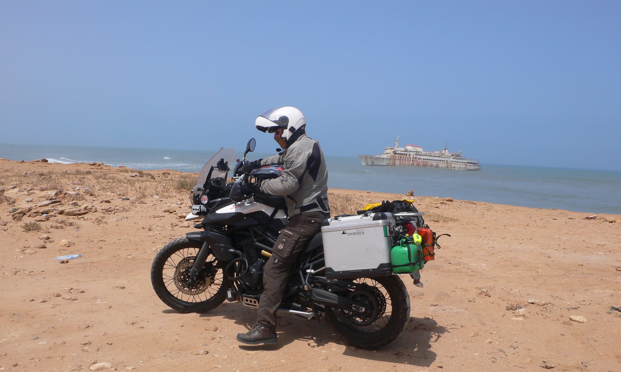
Then we drove up North along the skeleton coast for a day trip. The Skeleton coast derives its name from the countless shipwrecks that line its treacherous coast. Even if the sailors reached land they were doomed as there was no civilization. We saw the remains of one wreck, an Angolan fishing trawler “the Zeila”, that wrecked in 2008 during one of the many storms.

The shipwreck of “The Zeila” fishing trawler

Giving water from our Bakkie to a local guy
We had to replace 3 of the locks on the canopy of de Bakkie. Bushlore, the hire company, sent them down to a small repair garage in town. Went there and was confronted by a sign on the wall saying, “Bikers Church”. The owners, a father and son, were bikers and Dad was a preacher. Got invited to the service the next morning Sunday, so we dropped in, met up with some really interesting people.

Fixing the locks on our Bakkie

Swakopmund garage Bikers Church

After Sunday service in Bikers Church

Am glad that somebody knows how this thing works…. Susie my private driver, on the way to Sossusvlei
Next on the list was the Sossusvlei, the world’s oldest desert, home to Big Daddy, Deadvlei and Dune 45. Sossusvlei means dead end marsh. Vlei is Afrikaans for marsh and Sossus is Namara for no return or dead end. Sossusvlei is really a salt/clay pan surrounded by red dunes. Big Daddy is the tallest dune, being 325 meters high. Deadvlei is a forest frozen in time. It really is a weird sight. It’s a hike across some dunes and then down in a dip, it is a white dried-up marsh surrounded by red dunes. But the most bizarre thing is the 900-year-old skeletons of black trees standing sentinel in sharp contrast to the red dunes, white marsh, and blue sky. A forest frozen in time. But well worth the stiff hike there and back again. We went into the desert just before dawn. We stopped at Dune 45 as everyone else was racing to take a photo of the sunrise over Big Daddy. There was no one at Dune 45. I climbed this dune and watched the sunrise.

Desert road to Sossusvlei

Road to Sossusvlei

Left my mark on the Tropic of Capricorn

Suzy too
On the way to Sossusvlei we got a puncture on a desolate piece of road with little or no traffic, the C14 about 20Kms from Solitaire. The roads are liberally littered with sharp stones and punctures are a reality. This was a real challenge. I messed up the high lift jack and it got jammed in “de Bakkie”. We had another hydraulic jack that I used to lift the beast. This meant placing it under the rear axle which meant that I had to crawl on the dust and sand. I freed the high lift and just jacked it up with the hydraulic one. Whilst I was busy a convoy of 5 jeeps roared past really close to us, spraying us with dust and sand, they didn’t stop. I later learned that they were a Polish group. This is a major sin in the desert. You always stop to offer assistance. A young German couple stopped but they had a really young baby, so I told them to carry on. The next people to pass also stopped and they were a great help. A young French couple who had gotten a puncture the day before, so they knew what to do. I was really grateful to both the German couple and the French; they were the only people to pass. The wheels of the bakkie weigh a ton and it was hot and there was no shade.

Wonder where they go…. Puncture on a desolate stretch of road by Sossusvlei

This young French lady making sure that we do it right … she knew where that big round black thing went.

Sossusvlei dawn

The red dunes of Sossusvlei at dawn

Dune 45 all to ourselves

Race you to the top!

Halfway to the top

Me on the top

Then down on Dune 45

Sunrise from Dune 45

Sunrise at Sossusvlei

Sossusvlei

The road to Deadvlei

Big Daddy Dune in the background

Deadvlei

Deadvlei

A helping hand, couple was stuck in the sand

More dunes Sossusvlei

Back at the camping for breakfast, a visitor
We left Sossusvlei in the early afternoon for a 580 km run to Fish river Canyon. But first we stopped at a tyre repair shop to get the puncture fixed. This turned out to be two gnashes on the side, sharp stones. This meant a new tyre, which they had in stock. All in all, we were late leaving Sossusvlei, and we were tired and faced with a long run over what was for the greater part gravel roads. We made a 30km detour to check out a Nature camp site down a sand track, but their prices were crazy plus they were booked up. It was a major Yuppie place catering to the rich adventure seekers, got out of there as quickly as possible.

Getting a replacement tyre

Gravel roads to Betta camping

Amazing scenery

Zebras again!

Our little detour of 30 Km!

Our reward for the detour… Onyxes
We made it to a really nice little roadside camping, called Betta campsite. It was on the junction with the D826 and the C27 and a whopping 175km from Sossusvlei. It was a petrol station cum camping, cum chalets, cum shop and restaurant. We got the last spot and slept like logs. It was a really beautiful place.

Betta camping

Gorgeous homemade cakes at Betta

Sunset at Betta camping

Night sky at Betta camping
Then on to Hobas camping at Fish River Canyon 400km down some more tracks. We stopped for lunch and diesel in a town called Bethanie. Once again, the scenery along the C roads was just spectacular, there are no words to describe it, or the momentary chance meetings that we have with the inhabitants. This is what makes travelling so really fantastic.

Spectacular scenery on C roads

Chance meetings

Mountains of piles of rocks

Spectacular table top mountains

River, a rare sight

Table top mountains
We got a camping place on the NWR (Namibia Wildlife Reserve) camping site. That evening the Polish group arrived en masse, driving like lunatics on the campsite road. They crowded together hedging in a young Dutch couple. The Polish just take over, they talk to no one and just drink and make noise. We are on a Nature reserve where the night sky is beautiful and the sound of the nocturnal animals make for a really super time…… BUT the Polish group don’t heed this and just get drunk, play music, and talk loudly. The Dutch couple upped camp and moved down beside us.

Our NWR Campsite at Fish River Canyon

Baboon at campsite
The next day it was off to explore the Canyon. Nearly all the rivers in Namibia are dry and only have water in them, occasionally, after the scarce torrential rainfalls in the rainy season.

Fish River Canyon

Fish River Canyon

Remembrance piles of stones Fish River Canyon
One strange sight that we kept seeing was large cone shaped towers made from the surrounding sand. These are massive termite hills. Some of these were huge. They are built by tiny 2 centimeter long white and beige termites. The Queen is a lot bigger. The termites are divided into workers and soldiers. They feed the queen and remove the eggs, around 300 a day, who never leaves the nest. The termites don’t live in the mounds but live underground. The mound is a massive thermostat controlling the temperature in the hive. They also have a waste recycling program. The waste is turned into fungi and giant mushrooms grow at the base of the cones in the rainy season. These are gathered by the locals and eaten as a meat substitute or sold along the roadside.

Giant termite hill
Now it was time to head on, back up to Windhoek, 670 km away. First was the C12 then the D545 both gravel and then onto the tarmac B4 and B1, leading back to civilization. We stopped off for the night at the Hardap Dam and national park. Got a really nice camping spot and were treated to a really nice sunset. The Hardap Dam and water management project temper the flow of the fish river and supply drinking water to the surrounding areas. Construction of the dam was completed in 1963. However, the dam poses a real threat of flooding to Mariental and the surrounding area when the sluices have to be opened after heavy rainfall. The last flood occurred in 2006. Now the reservoir is kept permanently at 70 % capacity. Reeds growing in the Fish riverbed slow down the water flow of the river and increase the risk of flooding.

On C12

Relaxed driving

Sunset at our camping at Hardap Dam

Hardap Dam

Hardap Dam
We also wanted to stop at a place called Rehoboth, to camp along the lake. But after a look at the campsite, we decided against it, It was full for the weekend with party types, not our scene. Then the weather changed and for me it was a déjà vu. When I was travelling up to Windhoek it rained and now again.

Nearing to Windhoek… rain!
All the camping sites close to Windhoek were booked up, so we took a room in a traveler’s hostel called Chameleon, a place shared by both backpackers and fully equipped jeeps.

Chameleon Hostel
We were booked into Bushlore Sunday morning to return De Bakkie and more importantly to be reunited with Tiggy moondust. The return went smoothly, and I am really proud to say that there was not a dent or scratch on De Bakkie. Bushlore took our luggage and Susie to the apartment that we rented in Windhoek, and I followed on the bike. The next couple of days were spent looking around and doing the tourist souvenir shopping thing.

Putting all my luggage back onto Tiggy Moondust

Sunset in Windhoek
To share in even more in this incredible road trip, click on the like named photo album on my Facebook page. The album is divided in two. The second album is called Wildlife of Namibia and this album contains only the animals that we encountered on the trip. So, get yourselves an extra big slice of cake and a nice big mug of tea, prop up the cushions in your favorite chair and join us on a journey through Namibia.
Photo album Namibia 25-02-2023 to 22-03-2023
Photo album Wildlife of Namibia
Thank you for following, commenting, and liking. Thank you for sharing my journey, I appreciate it. My real time location is Windhoek, heading to Botswana.
Hasta la vista amigos